Some thoughts from one of the Committee about the effect of global warming on the Town
CIARAN GIVES US ALL A STERN LESSON a reflection by Ian Redding – 6 Nov 2023
Storm Ciaran has given us a timely reminder of what we must increasingly expect as global warming increases the volume and ferocity of Hurricane Season in the Caribbean and the US Eastern Seaboard.
Those hurricanes create most of our autumn and winter storms and Ciaran has highlighted what the consequences we will be facing as increased rainfall combines with rising sea levels. As Ciaran moves away, its place is being taken by Debi: let’s hope she will be a little kinder to us.
Ciaran was one of the worst storms of recent years creating occasions when Deal and Walmer became isolated from surrounding areas as flooding on local roads (both back-lanes and the main routes) made them impassable. Two days later and those roads now seem okay, but the surrounding ground where the water has run off the concrete and tarmac is saturated. If more heavy rain is expected it will have nowhere to go, so this winter could prove to be a bad one. Action is needed now.
Why am I telling you this? What are we expecting in the years ahead? The clue goes back 2,000 years.
What The Romans & Saxons Saw
When the Romans arrived in Kent (and the Saxons & Jutes after them) Thanet was an island with shingle banks leading to and from it; they built forts at Reculver and Richborough to protect the channel between Thanet and the mainland, and it was possible to take ships up past Fordham to Canterbury itself.
The town of Deal did not exist but the area provided solid enough ground where Lower Walmer now stands for Julius Caesar to think it a safe landing point. But where North Deal now sits was the end of one of those shingle banks and beyond that a mix of marsh and open sea. In Saxon times it is understood that boats were built at Great Mongeham where the sea inlet reached to. The map below gives you a clearer picture of the image I am painting, the current coastline being shown faintly behind the old one.
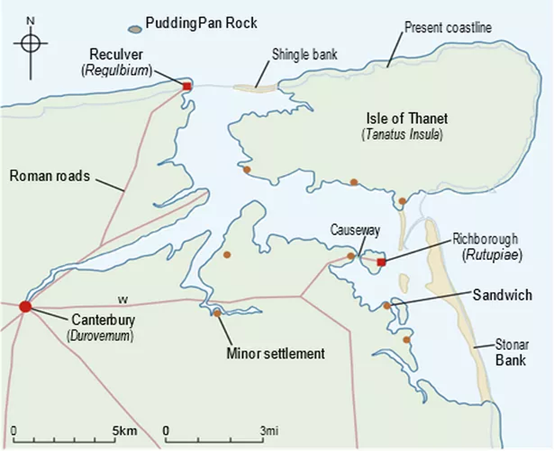
Over time, the movement of the gravel banks and the silting up of old rivers and watercourses, has turned much of the land of the Wantsum Channel into farming land, that is criss-crossed by drainage channels from Sandwich round to Reculver. Interestingly, there are very few roads crossing over that drained area …. the new Thanet Way, the old Roman Road from Thanet to Canterbury, and the Sandwich to Ramsgate road, and that’s it. But it’s quite a fragile balance and the clocks will be turned back as sea levels rise again.
What will the Kent Coastline look like with global warming?
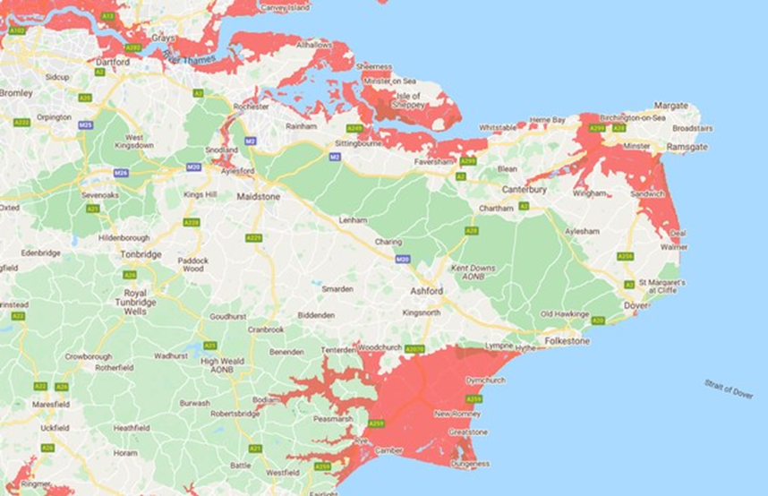
It is predicted that raised sea levels of around 2 meters would have devastating effects around the country, as this second map shows. Everything in pink is prone to flooding at high tide and, as you can see, the East Kent coastline looks very familiar to that illustrated above…. and Romney Marsh is no longer land either.
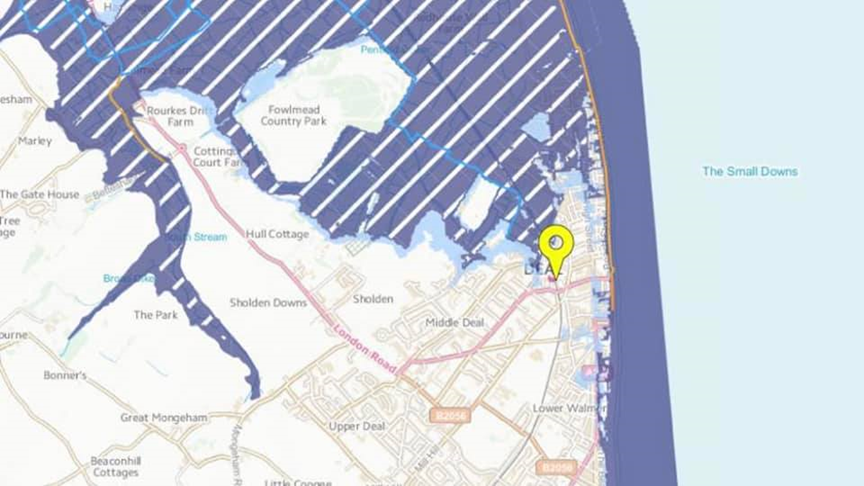
Taking that to a local Deal/Walmer level it creates a rather alarming scene, though it does seem like the shipbuilders of Great Mongeham will be finding employment again!
Joking apart, it raises important questions about planning, building, and regeneration in our local area which go beyond whether developments are on land liable to flood. Across the country there are increasing concerns that concreting and tarmacking over so much of our ground to provide new homes creates the problem of swift run-off of surface water into water courses and onto the flood risk land, and an associated inability to both drain the land and to remove sewerage and other foul water.
This is all very much on our doorstep and is rapidly becoming a major issue. So, the time for action to ensure this is properly reflected in future decisions has to be….. NOW!!!